
African-led initiative wins overwhelming support as the United Nations encourages a shift away from the centuries-old Mercator projection
UNITED NATIONS, New York — The United Nations General Assembly has overwhelmingly endorsed a push to change how the world is represented on maps, supporting an African-led effort to replace the familiar Mercator projection in many general-purpose settings with maps that more accurately portray the relative size of continents and countries.
The “Correct the Map” resolution was adopted Friday, Sept. 4, by a vote of 164 countries in favor, one against and six abstentions. The United States cast the sole opposing vote, while Estonia, Georgia, Lithuania, Moldova, Serbia and Ukraine abstained.
The resolution was spearheaded by Togo on behalf of the African Group and supported by the African Union and advocacy organizations that argue the traditional Mercator world map has, for centuries, given people a distorted impression of Africa’s enormous geographic scale.
Why the Familiar World Map Is Distorted
The Mercator projection dates to 1569, when Flemish cartographer Gerardus Mercator developed it primarily to assist maritime navigation.
Its great advantage is navigational: straight lines on the map can represent constant compass bearings, making the projection extremely useful for sailors.
But that convenience comes with a major tradeoff. As locations move farther from the equator, their apparent size becomes increasingly exaggerated.
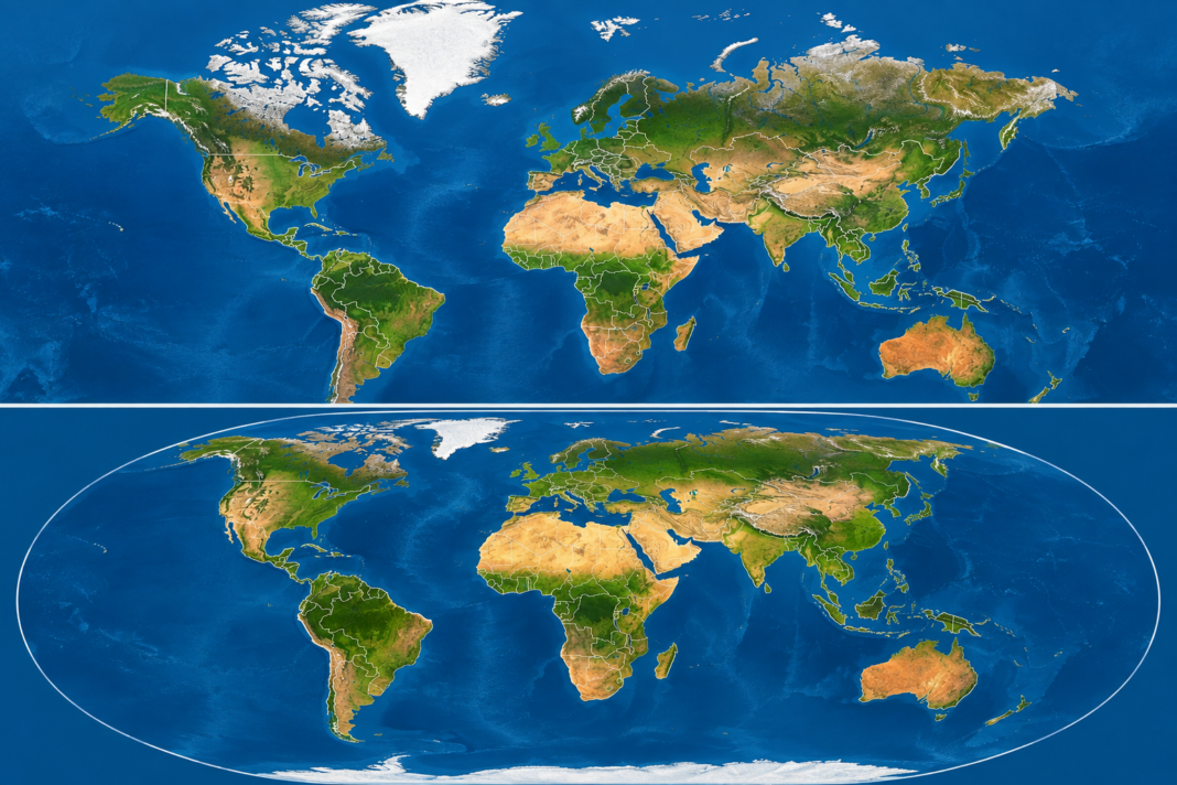
One of the most striking examples is Greenland and Africa. On many Mercator maps, Greenland can appear comparable in size to Africa. In reality, Africa is roughly 14 times larger.
The effect also makes parts of Europe, Russia and North America appear disproportionately large while reducing the visual prominence of Africa, South America and other regions closer to the equator.
That mathematical distortion is not disputed among cartographers. The controversy concerns what it means when a navigation-oriented projection becomes the world’s familiar mental picture of geography.
Africa Says Maps Shape Perceptions
Supporters of the initiative argue that maps do more than teach geography. They influence how societies perceive economic importance, political power, resources and the relative scale of countries.
Togo’s Foreign Minister Robert Dussey told the General Assembly that maps influence education, imagination and collective perceptions of the world.
The campaign maintains that repeatedly presenting Africa as substantially smaller than its actual relative area has contributed to what supporters describe as the continent’s symbolic minimization.
For advocates, changing the standard map is therefore partly about geography and partly about correcting a visual legacy they associate with centuries of colonial influence.
Equal Earth Offers a Dramatically Different Picture
The campaign favors the Equal Earth projection, introduced in 2018.
Equal Earth is an equal-area projection, meaning that the relative areas of countries and continents are preserved. As a result, the familiar world looks noticeably different.
Africa becomes much more imposing. South America also appears larger relative to northern regions. Greenland shrinks dramatically, while Europe, northern North America and Russia lose some of the visual dominance they have on Mercator maps.
That does not mean Equal Earth produces a perfectly undistorted flat map.
No two-dimensional map can reproduce a spherical planet without compromising some combination of area, shape, distance or direction. Mercator preserves angles and is valuable for navigation; Equal Earth prioritizes accurate relative area while necessarily altering some shapes.
The debate is therefore less about declaring one projection universally “correct” and more about choosing a projection appropriate for its purpose.
UN Vote Does Not Ban Mercator
Despite descriptions of the decision as the United Nations adopting a “new world map,” an important distinction remains: the resolution does not outlaw the Mercator projection or legally require countries to abandon it.
Instead, the nonbinding measure encourages governments, schools, international organizations, media institutions and technology companies to use Equal Earth or other appropriate equal-area projections when portraying the relative sizes of the world’s regions.
Mercator can therefore continue to be used where its particular properties are valuable, especially for navigation.
The resolution instead challenges its role as the default general-reference image of the planet.
France Moves Away From Mercator
France was among the countries supporting the broader push for more geographically proportional maps.
French Foreign Minister Jean-Noël Barrot announced that French diplomacy would move away from Mercator. France is adopting the Eckert IV projection, another equal-area approach, for its diplomatic cartography rather than simply switching every map to Equal Earth.
The change means France, along with countries such as the United States and Russia, appears smaller relative to nations closer to the equator than on traditional Mercator maps.
United States Casts the Only No Vote
Washington stood alone in formally opposing the resolution.
The United States argued that the initiative placed unnecessary ideological considerations into the work of the United Nations. U.S. representative Yaryna Ferencevych criticized the proposal as part of what Washington viewed as a broader ideological agenda and argued that the institution should concentrate on international peace, prosperity and relations among nations.
Supporters countered that correcting misconceptions about the physical dimensions of countries is itself an educational and representational issue worthy of international attention.
The lopsided 164-1 vote demonstrated broad international support for the initiative despite the disagreement over its political symbolism.
A Different Way of Seeing Africa
For Africa, the change can be visually startling.
At approximately 30 million square kilometers, the continent is vast enough to contain the United States, China, India and several additional countries within its land area.
Yet generations of students accustomed to Mercator maps can easily underestimate that scale.
The implications extend beyond Africa. Brazil and the rest of South America gain greater visual prominence under equal-area projections, while the enormous apparent size of Greenland and far northern territories is reduced.
For supporters of the campaign, that difference matters because the map hanging in a classroom, appearing behind a television presenter or displayed on a digital platform can become a person’s unconscious reference for how large and important different parts of the world are.
More Than a New Map
The United Nations vote will not immediately cause every classroom map, atlas or digital mapping service to change.
But it gives substantial international backing to a movement that wants equal-area maps to become more common in education, media, international institutions and technology.
Togo is expected to incorporate updated geographic representations into its educational materials and continue advocating for broader adoption internationally.
For more than four centuries, Mercator’s projection has been among the most recognizable representations of Earth.
The latest UN decision does not erase its historical importance or navigational usefulness. Instead, it raises a different question: When the purpose of a world map is to show people how much of the planet each country and continent actually occupies, should the map look more like the world it is trying to represent?
For 164 members of the United Nations General Assembly, the answer was yes.
The Haitian Tribune | World News